Atlases from the Maritime Museum > The Zee-Fakkel by Johannes van Keulen
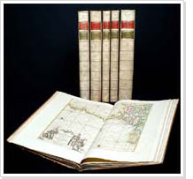 The Nieuwe Lichtende Zee-Fakkel ('New Shining Sea Torch') was one of the most succesful maritime atlases from the seventeenth and eighteenth centuries. Of this atlas, first published by Johannes van Keulen in 1681, many editions and translations kept appearing until the end of the eighteenth century.
The edition of the Zee-Fakkel used for The Memory dates from about 1790 and is a copy especially made for a specific customer. Almost all the maps have been coloured in by hand.
Apart from the maritime maps made by Vooght and four generations of Van Keulens, the six volumes contain maps by foreign cartographers such as Murdoch Mackenzie, who mapped the northern Scottish seas. The volume covering the Mediterranean also contains maps that were copied from the French shipping guide Le portulan de la mer Méditerranée by H. Michelot from 1709, of which a Dutch edition appeared in 1745.
The sixth volume, with maps of Asian waters, contains engravings of images and maps of Indonesian harbours, originating from the five volume work Oud en Nieuw Oost Indiën ('Old and New East Indies'), compiled by Francios Valentijn in 1724-1726.
The Van Keulen firm had bought the rights of both Michelot's and Valentijn's works.
